Last month, I wrote about how I used four primary sources—images and texts from revolutionary-era America—to introduce students to the concept of “cultural narratives” in my American studies course. Now I’d like to talk about another primary source discussion I found valuable this semester: one designed to shake up students’ mental picture of the United States at the end of the Revolution.
In 1783, around the time the American War was formally ending, the London publisher Carington Bowles released a “new map of North America and the West Indies” that attempted to capture the boundaries and larger context of the newly independent colonies. The Library of Congress has helpfully provided a high-resolution scan of the map, which has an almost alarming wealth of detail.
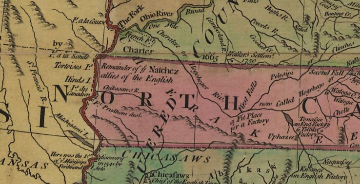
(To take an example at random: In what it considers western North Carolina, the map shows not only rivers and settlements but also notes about history and future prospects, labeling a “remainder of the Natchez allies of the English,” a putative location for the 17th-century Fort Prudhomme [“dest.”], and “a fit place for a [trading] factory.”)
In class, using the classroom computer and projector, I pulled up the map’s webpage.
On that page, without leaving a regular browser window, you can set the Library of Congress map viewer to full-screen mode (⤢) and use a regular mouse to zoom and pan quickly around the map. (Click and drag to move the map around; use the center scroll wheel to zoom in and out.) Assuming you have a good Internet connection and a reasonably fast computer, this gives you easy access to a huge image; the underlying archival-quality TIFF file is 489 MB.
I did this, and I spent some time looking around the map with my students, asking them what places in modern America they would especially like to examine.
This, I reminded them, is a Londoner’s view of what we think of as the United States, as it looked to him as the smoke of the Revolution cleared.
What, I asked my students, stands out to you about this map?
My students made a number of keen observations. The state boundaries are oddly shaped, they pointed out. All the states are different colors, and they seem to exist as separate things; they aren’t actually labeled “the United States.” The European empires are very much present across the continent and in the Caribbean. There are striking signs of geographic ignorance: much of the Great Plains is a “vast tract of land unknown.”
And there are Native American nations everywhere—hundreds of them, both inside and outside the boundaries of the U.S. states.
This, I suggested, is how we should understand what came into existence with the American Revolution: a contested and contingent new arrangement of political claims, mapped onto a small part of a continent controlled mostly by people who did not consider themselves citizens of the United States (or, in many cases, subjects of any European empire, either). The future of this thing, this set of things, was very much open.
In subsequent weeks, I’ve been pretty happy with the results of using this simple activity as a lens (one of several, of course) for viewing the American founding moment.
